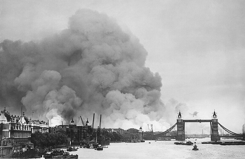
Faịlụ:London Blitz 791940.jpg

Otu nyochaa a ha:800 × 519 piksels Ndị ọzọ mkpebi:320 × 208 piksels | 640 × 415 piksels | 1,024 × 664 piksels | 1,280 × 830 piksels | 2,954 × 1,916 piksels.
Failụ si na nke mbu (2,954 × 1,916 pixel, ívù akwukwo orunótu: 1.21 MB, MIME nke: image/jpeg)
Ịta nke usòrò
Bìri èhì/ogè k'ị hụ òtù ụ̀fa dị̀ m̀gbè ahụ̀.
| Èhì/Ogè | Mbọ-aka | Ógólógó na asaá | Òjìème | Nkwute | |
|---|---|---|---|---|---|
| dị ùgbu â | 23:42, 30 Mee 2022 |  | 2,954 × 1,916 (1.21 MB) | Smalljim | Re-process original file. Rm blemishes, de-noise. |
| 03:06, 12 Disemba 2013 |  | 2,940 × 1,916 (2.97 MB) | G-13114 | Higher resolution | |
| 01:24, 10 Ọktoba 2010 |  | 750 × 468 (249 KB) | G-13114 | Reverted to version as of 01:05, 24 May 2008 | |
| 22:38, 7 Septemba 2010 |  | 625 × 390 (199 KB) | ALE! | Reverted to version as of 02:57, 18 December 2007 | |
| 02:05, 24 Mee 2008 |  | 750 × 468 (249 KB) | G-Man | Enlarged | |
| 03:57, 18 Disemba 2007 |  | 625 × 390 (199 KB) | G-Man | {{Information |Description= View along the River Thames towards smoke rising from the London docklands after an air raid during the Blitz. |Source= {{NARA-image|id=791940}} |D |
Ojiji faịlụ
Ihe ndị na-eso ihe eji Ihu akwụkwọ eme na faịlụ a:
Ejiji failụ zụrụ ọha
Wikis ndi a edeputara na eji kwa failụ a:
- Ihe eji na af.wikipedia.org
- Ihe eji na ar.wikipedia.org
- Ihe eji na ast.wikipedia.org
- Ihe eji na azb.wikipedia.org
- Ihe eji na az.wikiquote.org
- Ihe eji na be.wikipedia.org
- Ihe eji na bg.wikipedia.org
- Ihe eji na ca.wikipedia.org
- Ihe eji na de.wikipedia.org
- Ihe eji na en.wikipedia.org
- Ihe eji na en.wikiquote.org
- Ihe eji na eo.wikipedia.org
- Ihe eji na es.wikipedia.org
- Ihe eji na eu.wikipedia.org
- Ihe eji na fr.wikipedia.org
- Ihe eji na he.wikipedia.org
- Ihe eji na hr.wikipedia.org
- Ihe eji na id.wikipedia.org
- Ihe eji na ja.wikipedia.org
- Ihe eji na no.wikipedia.org
- Ihe eji na oc.wikipedia.org
- Ihe eji na pl.wikipedia.org
- Ihe eji na pt.wikipedia.org
- Ihe eji na ro.wikipedia.org
- Ihe eji na ru.wikipedia.org
Lee more global usage of this file.


